La Palma
La Palma
In the northwestern part of the Canary Islands archipelago, there is the island of La Palma, also known as Isla Bonita or Isla Verde, for its lush forests and extraordinary natural beauties. It has an area of 706 km². and a population of 80,000 inhabitants, spread over 14 municipalities. There are considerable heights on this island for such a short perimeter. Its maximum height is the Roque de Los Muchachos with 2,426 m., Although the entire central mountain range of the island exceeds 2,000 meters. The distance from Tenerife is 85 kilometers, while from the Peninsula (Cádiz) it is 1,440 km. Like the rest of the Canaries and other archipelagos that make up Macaronesia, it is of volcanic origin, distinguishing itself from all the others by the greenness of its mountains and the abundance of water, with La Palma being the only Canary Island that has streams or small rivers.
History
The conquest of La Palma for Spain begins on September 29, 1492, with the landing on the beaches of Tazacorte of the troops commanded by the advance Alonso Fernández de Lugo, ending on May 3 of the following year. The primitive settlers called their island Benaohare and it was divided into 12 cantons or lordships that ruled as many lords. The last Palmero king to submit to the invaders was the indomitable Tanausú, who ruled the kingdom of Aceró (Caldera de Taburiente). After the unsuccessful attempts by the Castilians to enter the Caldera to reduce him, Fernández de Lugo sent a certain Juan de Palma, a relative of Tanausú already Christianized, to convince him to leave through the Adamacansis pass to make a gentlemen's agreement. . This is what Tanausú did, true to his word as a knight, and was captured in an ambush in the place known today as El Riachuelo, near La Cumbrecita. Once the conquest was concluded, with the incorporation of the island of La Palma into the crown of Castile, Castilians, Majorcans, Catalans, Portuguese, Italians, Flemish, etc. began to arrive there. attracted by the riches of this land. All these people and the few indigenous people who surely remained form the trunk of the current palm tree population. Already in the sixteenth century, the island acquired a remarkable strength, the sugar mills or sugar mills are very active. Notable quantities of Malvasía wine, honey, and other products were also exported. The first shipyards were installed and the port of Santa Cruz de La Palma developed an intense commercial activity, with maritime links to Europe and America. This prosperity of the island attracts famous pirates and corsairs of the time, such as the French jambe de Bois (Pata de Palo and best crossbow), who in 1553 looted and burned Santa Cruz de La Palma, destroying important monuments and archives of the city. In the 18th century, the port of Santa Cruz is considered a third of the empire, after Antwerp and Seville. Ships are dispatched from it to America and the first court of the Indies is created in the palm capital. Special mention should be made of the shipbuilding favored by the abundance of wood in the island's forests. Shortly after the conquest, the first shipyards were installed, which were very active until the 40s of this century. Brave sailing ships like La Amistad, San Miguel Nivaria, Rosa del Turia, Ninfa de los Mares, La Fama, El Triunfo, La Verdad, etc. Of all of them, we must highlight La Verdad, admired in all the ports of Europe and America that he visited.
Weather
The climate is highly variable, depending on the area in which one is, taking into account that we are on an island with altitudes greater than 2,000 meters above sea level, and two well-differentiated areas: The northeast part is favored by the trade winds loaded with humidity and the southwest much drier and sunnier. There is an average temperature of 20 degrees throughout the coastal strip up to the level of 200 meters. Once we exceed this height, in winter, the thermometer descends as we go up, until it even reaches 0 degrees in the higher parts of the island. In summer, temperatures in the higher areas easily reach more than 30 degrees.
Rainfall and springs
It is the island most favored by the rains, due to its peculiar relief, the Atlantic storms affect it frequently. On the other hand, the entire northeastern strip is frequently affected by the trade winds, which form the sea of clouds, thereby producing the so-called "horizontal rain" -at the contact these with the trees, rain in the form of dripping of great importance for aquifers. Regarding pluviometric data, the southwestern coastal strip is the least rainy with 350 liters per year per m²., In midlands over 500 liters per m². and in upper-middle areas, they exceed 1,000 liters per M² per year.
On La Palma are the mainsprings in the Canary Islands and where there are the only streams with transparent waters. Those of the Caldera de Taburiente and Marcos y Corderos en los Sauces are the most important, as well as those of the Río ravine in Santa Cruz de La Palma. Since the conquest, these spring waters have been used as a source of energy for the sugar mills and the gofio mills.
Fauna and Flora
Despite the predatory hand of man since the conquest, the island still preserves important vestiges of vegetation. The most important is the northern laurel forests, such as El Cubo de La Galga and El Canal. Los Tilos is declared a Biosphere Reserve and protected by UNESCO. The Canary Pine also inhabits a large part of the island and its exploitation has been prohibited for years, so this species, which lives even in very poor lands, is spreading to lands that were usurped from it in another era. According to the botanist from La Palma Arnoldo Santos, the endemic flora of this island is made up of 70 species, another 104 are Canarian endemic species and 33 are Macaronesian. The rest until reaching 774 species are introduced or spontaneous. Among the palm endemic species, the Bejeques stand out, of which there are several classes, Cardoncillo (Ceropegla Hians), Violeta, or Pensamiento de la Cumbre (Viola Palmensis), the Tajinaste, also with several species, tagasaste, donkey thyme, etc. Of the legendary and famous Dragon Tree, endemism of Macaronesia, a remarkable amount remains on La Palma, the most important in the Canary Islands. Beautiful specimens of this unique tree can be seen in Las Breñas, Garafía, Punta Gorda ... But the most interesting mounds are in La Tosca (Barlovento) and in Butacas (Las Tricias).
706 km2
superficie
+18º/ +24º
Temperatura
Santa Cruz de La Palma
Capital
18
Lugares de interes
places of interest

Breña Alta
The municipality of Breña Alta is located in the east of the island of La Palma. It has an area of...
+ Information
Breña Baja
Breña Baja is located in the east of the island of La Palma. It has a coastline length of 7.28 km...
+ Information
Caldera de Taburiente
Para empezar, La Palma cuenta con una naturaleza privilegiada, que ha merecido su declaración como...
+ Information
Cubo de la Galga
The La Galga ravine is located in the northeast of the island and in the municipality of...
+ Information
Isla La Palma
La Palma is a haven of peace and a paradise for the senses. Known as the 'Isla Bonita' (Pretty...
+ Information
Los Bosques encantados de los Tilos
Los Bosques encantados están ubicados en la reserva natural de Los Tilos, en el Noreste de La...
+ Information

Los Llanos de Aridane
Los Llanos de Aridane es la segunda ciudad más importante de La Palma y con 20.948 habitantes es...
+ Information
Miradores y senderos de La Palma
A su vez, el impresionante relieve de La Palma ha permitido la creación de una amplia red de...
+ Information
Monumento Natural de los Volcanes de Aridane
Grandes ejemplos de vulcanismo antiguo son los cráteres que forman el Monumento Natural de los...
+ Information
Playa de Tazacorte
La Playa - puerto de Tazacorte está situada en el municipio de Tazacorte. Se trata de una playa...
+ Information
Playas de La Palma
Para hablar de las playas de la isla podemos dividirlas en cuatro zonas, las del oeste enclavadas...
+ Information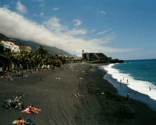
Puerto Naos
Puerto Naos es una de las dos villas turísticas con las que cuenta la costa oeste de La Palma. ...
+ Information
Puntagorda
Puntagorda es un municipio español situado en el noroeste de la isla canaria de La Palma....
+ Information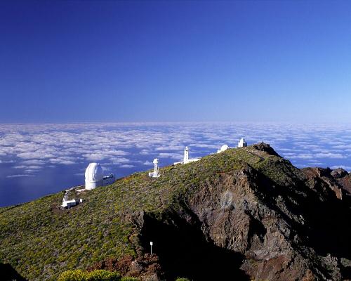
Roque de Los Muchachos y Observatorio
El Roque de los Muchachos es el nombre que se le da al pico rocoso más alto de la isla de La...
+ Information
Santa Cruz de la Palma
La ciudad de Santa Cruz de La Palma se encuentra situada en la vertiente oriental de la isla de La...
+ Information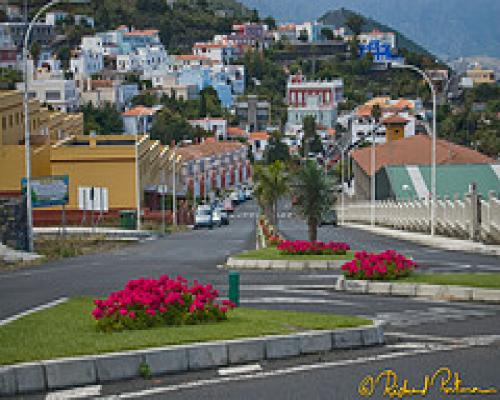
Villa de Mazo
Villa de Mazo es comúnmente conocida como Mazo, está localizada en el sureste de la Isla de la...
+ Information
Volcán de San Antonio
Este cráter realizó su gran erupción en el año 1677. Actualmente se encuentra dentro de las...
+ Information